
How coordinated is your city in a crisis?
E-Afet City brings municipalities, field teams, critical service units and citizens together on one operational resilience platform.
From pre-disaster preparedness to crisis-time coordination, from field management to citizen communication: manage your city's entire operation from a single centre.
- Operational Resilience Platform
- Network-Independent Communications
- Real-Time Crisis Management
- Powered by Türkiye's first underground data centre infrastructure
- Backed by the Ministry of Industry and Technology
Why do city operations get harder in a crisis?
Broken communication between institutions
No real-time visibility of field teams
Citizen reports that cannot be verified
Resources and teams that cannot be directed to the right place
E-Afet City brings scattered information and operations together under one shared view.
How does the platform work?
Senses
Collects data from sensors, GÖZCÜ, field teams and citizen reports.
Interprets
Builds a holistic view of the situation with geographic information systems, artificial intelligence and multi-risk analysis.
Coordinates
Manages teams, resources, logistics and operations from a single centre.
Informs
Sends verified, targeted and real-time notifications to citizens and the relevant institutions.
Core use areas
The capability groups this package leads with. Each one opens onto its module in the platform.
Command and Operations
- Central control panel
- Incident and task management
- Field team tracking
- Mobile team coordination
- Resource and logistics management
- Cross-agency operational visibility
Manage city-wide incidents, teams and resources from a single screen.
Explore the moduleMap and Situational Awareness
- Live city map
- Critical facilities and risk points
- Assembly areas
- Closed and safe routes
- Incident density maps
- Geographic information system visualisation
See what is happening where, assess the risks and direct the field correctly.
Explore the moduleEarly Warning and Risk Monitoring
- GÖZCÜ early-warning infrastructure
- Sensor and field data monitoring
- Multi-risk analysis
- AI-assisted assessment
- Automatic alerts and escalation
- Critical threshold tracking
See risks before they become a crisis and act early.
Explore the moduleCitizen Communication
- SOS alarm
- I'm Safe check-in
- Help requests
- Location sharing
- Verified push notifications
- Regional alerts
- Citizen feedback
Make citizens an active stakeholder in crisis management, not just an audience to be informed.
Explore the module
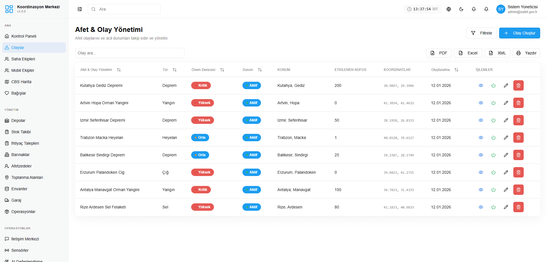
Every incident is an open record.
The disaster and incident management screen: incidents by province; type, severity, status and affected population in a single list. Records export to PDF and Excel. Captured from the demo environment.
Value for every stakeholder
Municipal Management
Gains a shared operational view of the entire city.
Disaster Coordination Units
Speeds up coordination across institutions, teams and resources.
Field Teams
Access tasks, routes, risks and incident details on the move.
Citizens
Receive verified information, request help and share their safety status.
Campuses and Large Residential Sites
Manage crisis response, safety and evacuation across enclosed or large areas from a single centre.
Critical Service Units
Monitor energy, transport, health, water and communications operations on a shared system.
Scenario-based use
The same flow adapts to:
- Flooding
- Wildfire
- Large-scale power outage
- Industrial accidents
- Severe weather
- Mass events and crowd management
Earthquake scenario
The system collects warnings and field data.
Critical zones are marked on the map.
Field teams are assigned automatically.
SOS and I'm Safe notifications arrive from citizens.
Assembly areas and safe routes are shared.
Municipal management monitors the entire operation from a single centre.
Crisis management above the city.
Data security below the ground.
E-Afet City aims to run critical city data and crisis operations on secure, uninterrupted and resilient infrastructure.
Positioned alongside Türkiye's first underground data centre project, the platform helps protect critical data to a higher standard against physical threats, disasters and infrastructure outages.
From Smart City to Resilient City
A smart city is not just a city that monitors traffic, energy and infrastructure.
A truly smart city is one that can communicate in a crisis, take decisions quickly, direct its resources to the right place and act in coordination with its citizens.
E-Afet City turns the smart-city approach into a concrete management model built around operational resilience, crisis management and citizen safety.
Start Your City's Resilience Journey